|
 |
| |
 |
Display in Digital Maps |
|
| |
|
| |
One of the GeoClustering® most valued features is its simplicity for viewing and interpreting data: it shows the results of highly complex statistic models, in a simple manner. Its friendly user operation and the display of the information on a map in different colors is far more easy to interpret than spread sheets, because it allows viewing “snap shots” of the different markets. |
| |
|
| |
|
| |
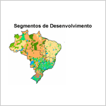 |
| Example: |
|
| |
| GeoClustering® Brasil. Regional development indicators. |
| |
 |
|
|
| |
|
| |
 |
| Example: |
|
| |
| GeoClustering® Gran Buenos Aires. |
| |
|
|
|
| |
|
| |
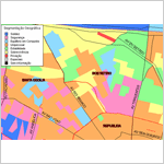 |
| Example: |
|
| |
| GeoClustering® San Pablo, city micro zone. |
| |
|
|
|
| |
|
| |
|
| |
A detailed explanation about GeoClustering® is available. Contact us. |
|
|
|