|
 |
| |
 |
GeoClustering® Argentina |
|
| |
|
| |
GeoClustering® Argentina was carried out with SD&W proprietary models, using more than 1200 variables discriminated to the highest degree of precision, the smallest level of geographical information provided by National Census, and proprietary databases. |
| |
|
| |
To get a thorough explanation of GeoClustering® Argentina, contact us. |
| |
|
| |
 |
| Example: |
|
| |
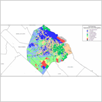
| GeoClustering® City of Buenos Aires. |
| |
 |
|
|
| |
|
| |
 |
| Example: |
|
| |
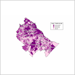
| GeoClustering® Gran Buenos Aires. Distribution of the factor “Household income and education level”. |
| |
|
|
|
| |
|
| |
 |
| Example: |
|
| |
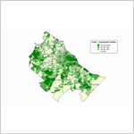
| GeoClustering® Gran Buenos Aires. Distribution of the factor “Family Composition”. |
| |
|
|
|
| |
|
|
Granularity Options |
|
| |
Every degree of granularity is developed with specific models, which allows performing from macro analysis to micro marketing actions. |
| |
|
|
The Whole Country |
|
| |
The entire Argentine Republic is taken as a universe, and the development, evolution and opportunities for each province are analyzed within the context of the whole country. |
| |
|
|
Provinces |
|
| |
Each province is taken as a universe and the different regions are analyzed within the province context. |
| |
|
|
Cities |
|
| |
GeoClustering® links the information about your customers with information about the market, discriminated to the highest degree of precision, the smallest geographic unit, the 8 digit postal code. |
| |
|
| |
This analysis covers the following areas: |
| |
• City of Buenos Aires
• 24 localities in GBA
• Rosario
• Córdoba
• Mendoza
• Tucumán
• Santa Fe
• Bahía Blanca
• Mar del Plata |
| |
|
| |
GeoClustering® on any other city can be performed on demand. Contact us. |
|
|
|